Thank you for visiting this site. My name is Jonathan.
So, what is a ‘Random Point‘?
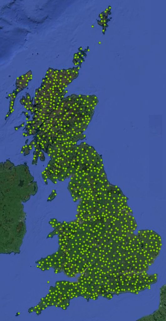
In 2015 I made a list of a thousand points randomally scattered across Britain, ‘RPs’. The rules were (1) each point had to be at least five kilometres from any other, (2) not in a nature reserve or other environmentally sensitive area, (3) not in seriously hazardous terrain or involve crossing such terrain to get there, (4) in a publicly accessible location, and (5) must not have the same name as any other point. If it is found when trying to visit a point that it violates any of these rules then the nearest location to the original grid reference which does adhere to them becomes the RP location.*
The list itself can be found here: LIST OF RANDOM POINTS.
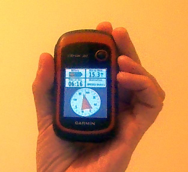
Most RPs are clearly defined in the list, but others are simply GPS locations, e.g. part way up a mountainside or on a beach. The use of a GPS device capable of giving 10-figure Ordnance Survey grid references is necessary to locate such places as accurately as possible. My preferred device is my beloved Garmin eTrex 20, but there are other brands and models on the market. Phone apps which give grid references or latitude/longitude are available, such as “Grid Ref OS” for Android devices in the Google app store.
There is one additional Random Point to the thousand in the above list: Watch Hill, nr. Cockermouth, Cumbria. It was included in an early version of the list but, for reasons I don’t recall, wasn’t in the final list. I did actually visit the location, so will record it here as an ‘honerary’ Random Point.
RP no. 0 - Watch Hill, 2 km (2.1 miles) ENE of Cockermouth, Cumbria [formerly Cumberland]. Grid reference NY 14756 31897, 209m (212 ft) above sea level. Visited 10 Oct 2015, 11:35 am.
I only got round to visited twenty-three of the locations on my list (plus Watch Hill), but have renewed my interest recently so am going give it another go, starting from scratch and have created this web site to record my progress.
Enjoy.
* The locations were identified by converting random numbers into geographical coordinates, plotting the points on a map and then finding the nearest point to each spot adhering to rules at the top of this page. Often points would fall in the sea, but if there was land withing one kilometre that was chosen. The latter might have give a slight bias in favour of coastal locations, but only very slight and I decided that was acceptible for aethetic reasons.
The grid references given in the list are based on the position as plotted on the relevant 1:25000 Ordnance Survey map (2015). When visiting a location I take a ‘WAAS/DGPS’ reading (a device setting which gives greater accuracy than GPS alone) at the specified location, and update THE LIST accordingly.
